-
 For the first time in over 25 years, there was no tropical storm in Atlantic basin over the Labor Day weekend, what does that mean as we approach the height of hurricane season?
 -
 What is expected to strengthen into Hurricane Ernesto is moving toward Puerto Rico, but forecasters say it will turn north and away from the U.S.
 -
 A storm system brewing over Cuba on Friday could bring torrential rain and flooding to the Florida peninsula this weekend. The forecast is expecially concerning for low-lying coastal and urban areas that were inundated in June.
 -
 Messy tropical wave to provide an uptick in rainfall starting this weekend. What are the chances of it developing?
 -
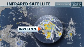
 The area of disturbed weather is in the central Atlantic and moving to the west-northwest.
 -
 Hurricane Beryl is roaring across the Caribbean Sea as a monstrous Category 5 storm on a path toward Jamaica and the Cayman Islands. At least four people have died after Beryl slammed ashore in the southeast Caribbean.
 -
 The National Weather Service estimates that from Tuesday through Wednesday about 20 inches (50 centimeters) of rain drenched the hardest-hit spots, including Hallandale Beach and Hollywood, and roughly the same amount in North Miami.
 -
 Travelers in and around South Florida were trying to adjust their plans on Thursday morning following more than 20 inches of rainfall since Tuesday. More rain is predicted over the next few days.
 -
 UPDATED: Dangerous flooding from a tropical disturbance inundated much of southern Florida, blocking roads, floating vehicles and delaying the Florida Panthers on their way to Stanley Cup games in Canada against the Edmonton Oilers.
 -
 NWS debuts experimental 'heat risk' product, asks users to weigh in.
 -
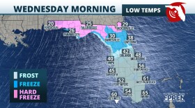 Sub freezing lows are forecasted for the Panhandle and North Florida this week. Wind chills in the 30s are expected as far south as Tampa and Orlando.
 -
 A severe weather system tracked across the Southeast this morning, and it spawned reports of tornadoes and damaging wind gusts across Florida’s Panhandle.
© 2024 WLRN
Play Live Radio
Next Up:
0:00
0:00
Available On Air Stations


